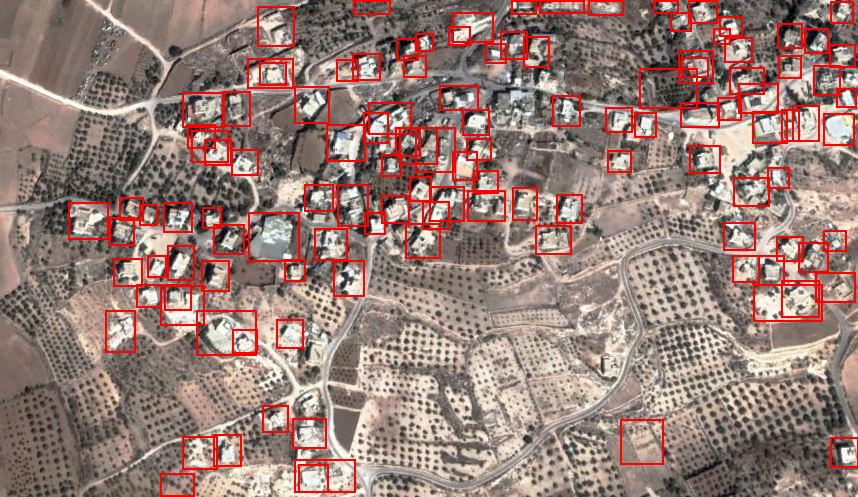
Introduction: In the dynamic field of computer vision and artificial intelligence, Azure Custom Vision emerges as a powerful tool revolutionizing urban planning and infrastructure development. A transformative project leveraging Azure Custom Vision was undertaken to recognize buildings in satellite images of low-density population zones. Through a simple Python script, buildings were tagged with red bounding boxes, demonstrating the potential of AI can be used for enabling data-driven decisions for urban planners, researchers, and other professionals using satellite imagery.
I chose to use low-density population areas because I assume training the model using less populated areas would be easier than high-population areas
Azure Custom Vision: A Key AI Enabler At the heart of this endeavor lies Azure Custom Vision, an integral component of Microsoft’s Cognitive Services suite. By empowering developers to create custom image classification and object detection models, Azure Custom Vision removes barriers to AI adoption. Its user-friendly interface allows developers to build tailored solutions without extensive machine learning expertise, making it a powerful tool for addressing diverse tasks in the field of computer vision. using azure custom vision was surprisingly simple once you get a basic understanding of how training computer vision works.
In the following image, we can see the simple UI of the custom vision service.

The Project: Recognizing Buildings with Precision Focused on building recognition in satellite images, the project began with painstaking data annotation. Low-density population zones were selected as the context for training the model. Four hours were devoted to meticulously marking buildings, laying the foundation for an accurate and robust AI model.
Below are the inserted image and the marked image
Input Image:

Output Image:

images for this project were taken from Google Earth (which allows the use of satellite images for research and nonprofit uses).
Notice – about 90-95% of buildings were recognized, in other images I usually got 85-ish% with a few false positives which is amazing considering this is the first computer vision model I trained myself with a relatively small amount of training hours.
The Art of Model Training The training phase, facilitated by Azure Custom Vision, took an additional two hours. Here, the model learned intricate patterns specific to buildings in low-density population zones. The result was an AI system capable of accurately recognizing buildings in unseen satellite images.
In hindsight, another hour or two would probably make the model a bit more accurate but the lemon isn’t worth the squeeze – diminishing returns are a problem when training computer vision models.
Scripting: Tagging Buildings with Red Bounding Boxes Through simple Python scripting, the trained model was operationalized for real-world applications. The Python script seamlessly integrated the model, efficiently analyzing new satellite images and precisely tagging buildings with red bounding boxes. This added visual clarity for further analysis and interpretation by whoever is looking at the processed file.
I’m quite satisfied with the short Python script I wrote – only 38 Lines of code(!)
View the project’s GitHub – https://github.com/DesertDust/automatic-waffle/
Key Capabilities Demonstrated:
- Building Recognition: The Azure Custom Vision model showcased its prowess in identifying buildings within satellite images with impressive accuracy.
- Scripting: The Python script facilitated seamless integration of the model, enabling building marking for insightful analysis.
- Context-Specific Learning: Training the model on data from low-density population zones showcased its adaptability to context-specific architectural patterns.
Future Possibilities: Unleashing the Full Potential Beyond this successful project, the AI journey continues, brimming with possibilities and applications:
- Multi-Class Object Detection: Extending the model to recognize various objects, such as roads, vegetation, and infrastructure, holds promise for comprehensive urban planning.
- High-Density Zones: With training data from high-density population zones, the model could adapt to urban landscapes with distinct architectural patterns.
- Real-Time Edge Deployment: Deploying the model on edge devices enables real-time building recognition, bolstering disaster response and monitoring applications.
Conclusion: The impactful integration of Azure Custom Vision into this project reveals the true potential of AI in urban planning and infrastructure development. With the ability to recognize buildings in satellite images of low-density population zones, Azure Custom Vision empowers decision-makers with critical insights. The project’s success, combined with future possibilities, positions Azure Custom Vision as an invaluable ally in crafting smarter, more sustainable cities of the future.


No responses yet